
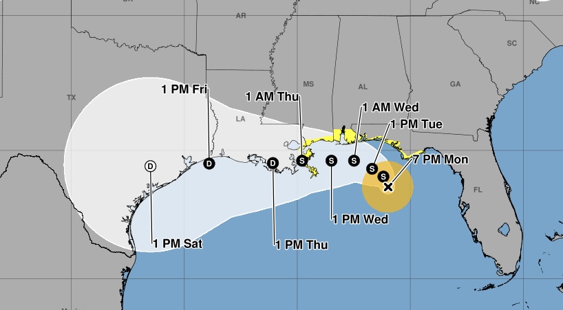
NOAA Hurricane Hunter aircraft have confirmed that the Tropical Depression Two in the Gulf of America has strengthened into Tropical Storm Bertha.
As of the 7:00 p.m. CDT advisory, Bertha was located about 110 miles south of Panama City, Florida, and 190 miles southeast of Mobile, Alabama. The storm was moving west-northwest at just 3 mph with maximum sustained winds of 40 mph and a minimum central pressure of 1004 millibars.
Forecasters expect Bertha to begin moving northwest tonight before turning west-northwest or west over the next several days, tracking near or along the northern Gulf Coast. Additional strengthening is possible through Tuesday.
A Storm Surge Watch remains in effect from the Alabama/Florida state line west to the mouth of the Mississippi River, while a Tropical Storm Watch extends from the Ochlockonee River in Florida westward to the Jefferson/Plaquemines Parish line in Louisiana.
For coastal Louisiana, including the Morgan City area, 1 to 3 feet of storm surge is possible if the highest surge coincides with high tide. Tropical-storm-force winds are possible across the watch area beginning late Tuesday into Wednesday.
Bertha is also expected to produce 2 to 4 inches of rainfall, with isolated totals up to 8 inches, across portions of the Gulf Coast through Friday. Southern Louisiana is included in the forecast area, where localized flash flooding, especially in urban and low-lying areas, will be possible.
Residents along the Gulf Coast are urged to closely monitor the latest forecasts and be prepared for additional watches or warnings as Tropical Storm Bertha approaches.