The much-advertised extremely cold arctic air mass began working into the region this morning with temperatures falling into the 30s along with 30+ MPH wind gusts. Temperatures will climb into the 40s this afternoon before falling quickly this evening into the 20s with wind chill values in the teens. A similar temperature scenario is expected again Monday.
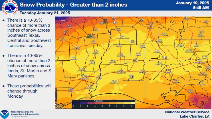
Probabilities for a potentially historic snowfall event across the region Tuesday continue to increase with swaths of the area expected to see between 2-6 inches of accumulation. Some forecast models depict accumulation totals even higher. There remains a comparably low (about 20%) chance of freezing rain accumulation generally along and south of the I-10 corridor Tuesday.
The National Weather Service says that something to keep in mind is that with wind gusts of 30+ miles per hour and expected ongoing snow, parts of the area may approach blizzard warning criteria (35+ MPH wind gusts and 1/4 mile visibility from heavy snow). While it is unlikely we will actually reach this criteria, expected conditions are close enough to make it worth mentioning.
NWS says to be aware that with temperatures expected to remain at or below freezing from early Tuesday evening until at least Thursday afternoon, any snow or ice that accumulates will not begin to melt until at least Thursday afternoon and shaded areas with significant accumulation may continue to see ice or snow through as late as Saturday.
Governor Jeff Landry is urging motorists to stay off the roads as much as possible as driving conditions may remain hazardous for several days as temperatures will dip below freezing.