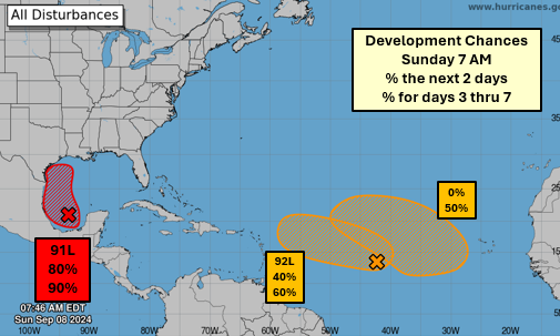
UPDATE: Sunday, 9-8-24: Air Force reconnaissance data indicate that maximum sustained winds are near 50 mph (85 km/h) with higher gusts. The system is expected to become a tropical storm on Monday, with more significant intensification forecast to occur on Tuesday. The system is
forecast to become a hurricane before it reaches the northwestern U.S. Gulf Coast.
ORIGINAL STORY: Local officials are asking the public to prepare for what is expected be a tropical system developing in the Gulf of Mexico this week. Forecasters now give the area of disturbed weather a 90% chance of development.
Jimmy Broussard, Director of St. Mary Parish Office of Homeland Security and Emergency Preparedness, issued a statement Sunday afternoon urging the public to be ready, “The public is urged to be weather-aware of the approaching storm system that will have some impact on St. Mary Parish. Please start making preparations now with any outside work that needs to be done. We will encounter lots of rain and some winds. Its too early to talk about the strength yet, but we will keep you informed. Those along coastline should also make preparations.”
Jay Grymes, Louisiana State Climatologist said Invest 91L in the Southwest Gulf of Mexico remains disorganized, but conditions will be favorable for development as the disturbance slowly drifts north-to-northwest over the next 2-3 days.
He added that a landfall in Mexico or Texas is becoming less unlikely, with the majority of the model guidance keeping the slowly-organizing system over the western Gulf waters. 91L is likely to become Tropical Depression #6 soon and could become Tropical Storm Francine in the next 2-3 days.
North-to-Northwest movement will be slow and the system may only be east, or even southeast, of Brownsville by Wednesday morning. After that, the potential storm will begin a turn to the north-to-northeast and start to increase its forward speed. Grymes said that puts Louisiana in the crosshairs for a landfall, most likely either late Thursday or early Friday, depending on the rate of increase in forward speed after Wednesday.
At this stage, landfall at tropical-storm intensity is most likely, but Grymes said given how we’ve been seeing storms “over-achieve” with respect to NHC forecasts, planning for a Category 1 hurricane would be prudent.

