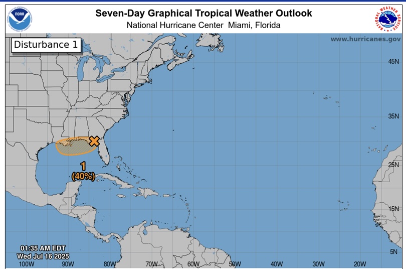
An area of low pressure has moved into the northeast Gulf. Conditions should remain favorable enough to support some gradual development as the low travels west along the northern Gulf coast. There is a 40 percent chance that it will become a tropical depression before reaching southeast Louisiana on Thursday. Regardless of development, the main threat from this feature will be heavy tropical rains and flooding. While the low may bring some breezy conditions Thursday through Saturday, there is no categorical wind or surge risk with this system.
The highest rainfall totals and associated flooding risk have shifted slightly more toward coastal and southwest Louisiana.
Timing of the heavy rainfall and associated flooding risk has been refined to focus on today through Saturday with the highest threat being on Thursday and Friday. More information regarding the heavy rainfall threat each day can be found below.
This disturbance is still undeveloped and the location of highest rainfall totals are still fluctuating so further changes to the forecast could occur.
This disturbance is forecast to move west/west-northwest through the northeastern and north-central Gulf today and Thursday and move inland between midday Thursday and early Friday morning.
A Flood Watch is in effect across all of southeast Louisiana beginning at 1:00 pm on Wednesday and continuing until 1:00 am on Saturday and for south-central Louisiana beginning at 7:00 Amon Thursday until 7:00 pm on Saturday.
Confidence remains low that this system will develop into a tropical depression or stronger. Any development of this system would likely occur right along the coast, leaving very little time for it to strengthen before moving inland.
Confidence is medium to high that this system will bring a threat of locally heavy rain to southern portions of Louisiana, especially on Thursday and Friday.
Confidence is medium in the forecast rain totals along the coastal areas of southeast and central Louisiana, but confidence is lower for the forecast rain totals north of the I-10/12 corridor. We will continue to monitor for any last minute trends that could shift the axis of heaviest rainfall farther north, closer to the I-10/12 corridor.
Regardless of development, the system forecast to move through the Gulf will bring multiple rounds of heavy rain during the Wednesday through Saturday time frame, with the greatest threat Thursday and Friday.
The current forecast calls for 3-6″ across portions of southern LA (along and south of I-10/12 corridor) with potential for up to 10″ in some localized areas (especially along the coast) during the Wednesday through Saturday time frame. However, it is still possible the heaviest rainfall stays just offshore.
Ponding of water in low lying and poor drainage areas is likely, with potential for more significant impacts (such as water approaching low-lying structures) if the higher end rainfall totals are realized.
Tides are currently moving into a neap cycle (low range between high and low tide), which should keep any coastal flooding at bay through at least Friday.


